


JACKSON TWP Voting District, Guthrie County, Iowa
About
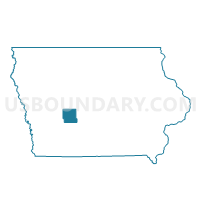
Outline

Summary
| Unique Area Identifier | 582208 |
| Name | JACKSON TWP Voting District |
| County | Guthrie County |
| State | Iowa |
| Area (square miles) | 33.68 |
| Land Area (square miles) | 33.68 |
| Water Area (square miles) | 0.00 |
| % of Land Area | 100.00 |
| % of Water Area | 0.00 |
| Latitude of the Internal Point | 41.61109780 |
| Longtitude of the Internal Point | -94.33530990 |
Maps


Graphs
Select a template below for downloading or customizing gragh for JACKSON TWP Voting District, Guthrie County, Iowa


Neighbors
Neighoring Voting District (by Name) Neighboring Voting District on the Map
- BEAVER TWP Voting District, Guthrie County, IA
- CASS TWP W/O YALE Voting District, Guthrie County, IA
- LINN TWP W/O LINDEN Voting District, Dallas County, IA
- PENN TWP Voting District, Guthrie County, IA
- UNION TWP W/O DEXTER Voting District, Dallas County, IA
- VALLEY TWP PART W/O GUTHRIE CENTER Voting District, Guthrie County, IA
Top 10 Neighboring County Subdivision (by Population) Neighboring County Subdivision on the Map
- Cass township, Guthrie County, IA (2,410)
- Union township, Dallas County, IA (2,134)
- Valley township, Guthrie County, IA (1,823)
- Beaver township, Guthrie County, IA (599)
- Linn township, Dallas County, IA (539)
- Penn township, Guthrie County, IA (524)
- Jackson township, Guthrie County, IA (308)
Top 10 Neighboring Unified School District (by Population) Neighboring Unified School District on the Map
- West Central Valley Community School District, IA (5,805)
- Panorama Community School District, IA (4,664)
- Guthrie Center Community School District, IA (2,648)
Top 10 Neighboring State Legislative District Lower Chamber (by Population) Neighboring State Legislative District Lower Chamber on the Map
- State House District 47, IA (54,425)
- State House District 73, IA (32,505)
- State House District 58, IA (27,255)
Top 10 Neighboring State Legislative District Upper Chamber (by Population) Neighboring State Legislative District Upper Chamber on the Map
- State Senate District 24, IA (83,683)
- State Senate District 37, IA (66,229)
- State Senate District 29, IA (54,648)
Top 10 Neighboring 111th Congressional District (by Population) Neighboring 111th Congressional District on the Map
Top 10 Neighboring Census Tract (by Population) Neighboring Census Tract on the Map
- Census Tract 9503, Guthrie County, IA (4,363)
- Census Tract 9501, Guthrie County, IA (4,296)
- Census Tract 506, Dallas County, IA (2,987)
- Census Tract 505, Dallas County, IA (2,117)
Top 10 Neighboring 5-Digit ZIP Code Tabulation Area (by Population) Neighboring 5-Digit ZIP Code Tabulation Area on the Map
- 50216, IA (2,824)
- 50115, IA (2,674)
- 50250, IA (2,330)
- 50233, IA (1,388)
- 50164, IA (652)
- 50146, IA (438)